

Until We Act
Aerial Archive of the Changing Himalayas
The Mountains Will Keep Changing
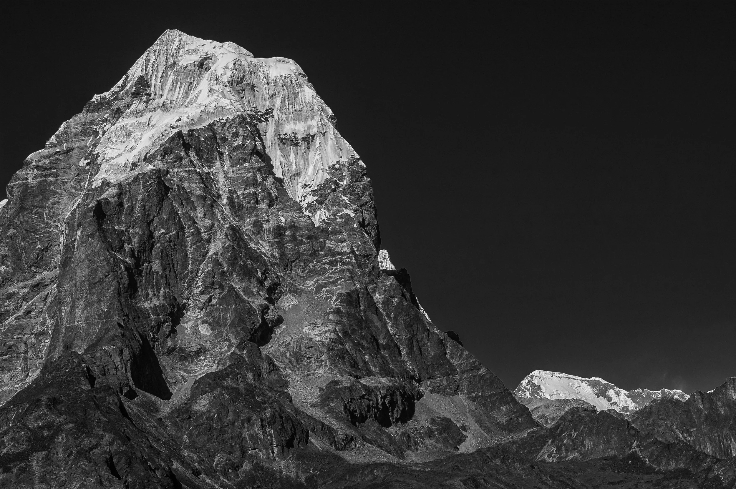
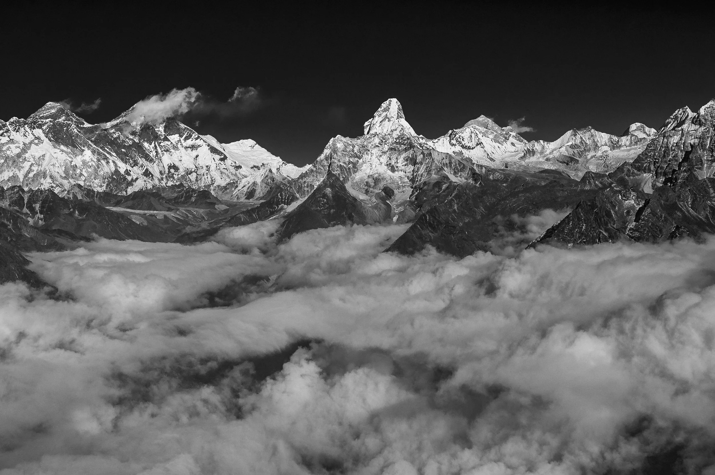
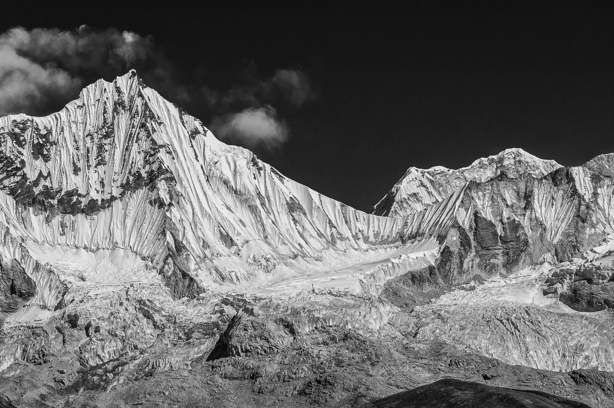
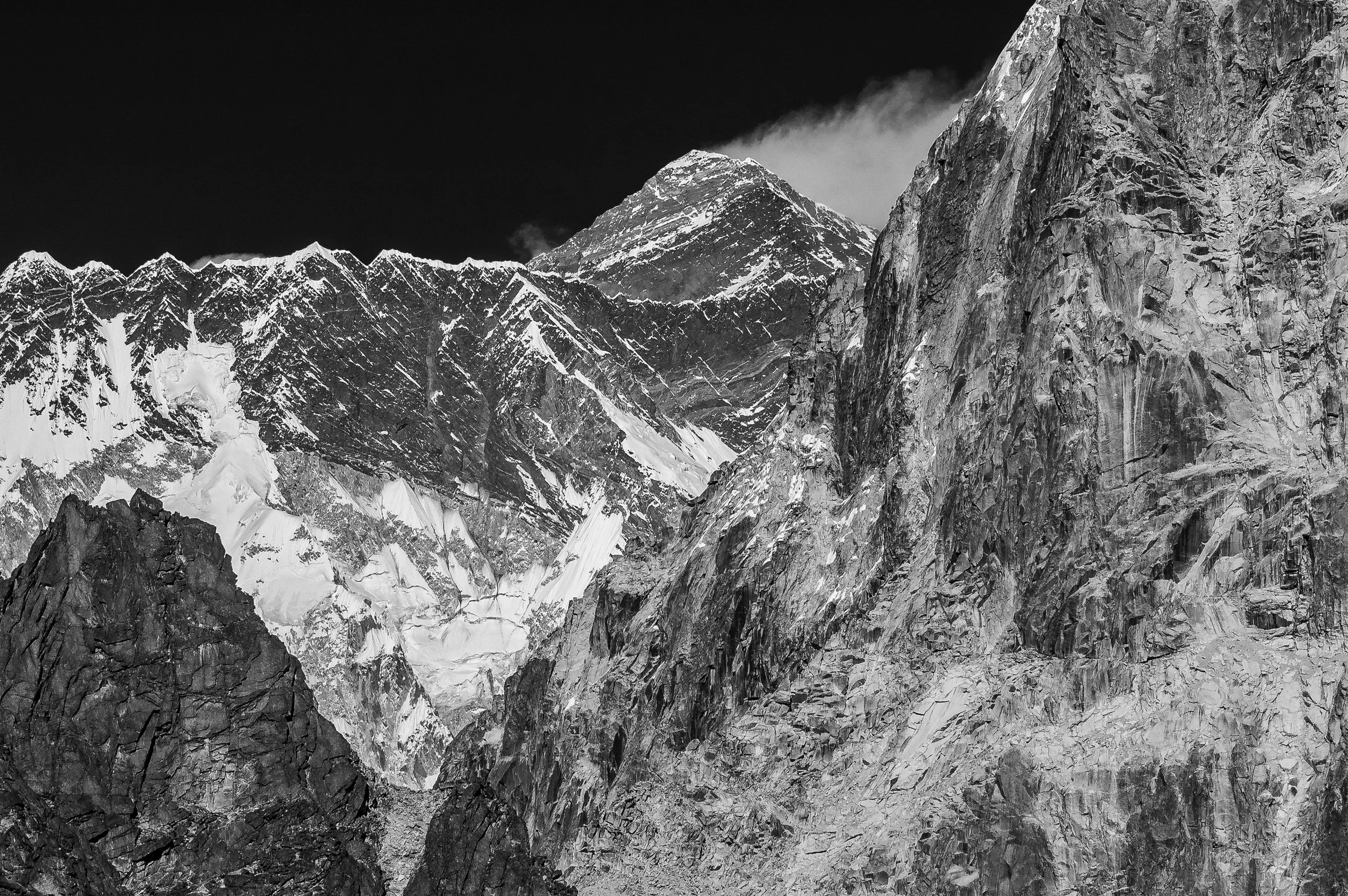
The Himalayas are changing faster than ever.
Glaciers are retreating, lakes are expanding, and landscapes that once felt permanent are now shifting within a single generation.
Until We Act is a long term visual and cinematic mission to document this transformation through aerial photography, open door helicopter missions, and documentary filmmaking across the entire Himalayan range.
This is not a single project.
It is a growing archive.
A visual record of environmental change across Everest, Annapurna, Kanchenjunga, Dolpo, and other major Himalayan regions.
Each flight and each expedition captures what is disappearing in real time.
Each frame becomes evidence.
Billions of people depend on Himalayan water systems.
As glaciers collapse and glacial lakes expand, entire ecosystems and communities are placed under increasing pressure.
Until We Act transforms environmental change into visual documentation that can be used for awareness, education, and long term research.
This is where photography becomes archive and evidence.

The project is created using:
Open door helicopter aerial photography
Medium format high resolution camera systems
Stabilized cinematic aerial platforms
Ground based documentary photography
Over a multi year period, thousands of images and sequences will be created across the Himalayan region of Nepal.
Everest Region
Annapurna Region
Kanchenjunga Region
Dolpo Region
Remote and high altitude Himalayan corridors.
Until We Act will form:
the largest aerial visual archive of the Himalayas
a fine art and documentary photography collection
a climate awareness visual record
a long term reference for researchers and educators
The project will be presented through:
Exhibition
A major fine art exhibition in Kathmandu followed by international touring shows.
Fine Art Book
Archival print publication documenting Himalayan change through aerial imagery.
Documentary Film
A cinematic narrative showing both the making of the project and the climate reality of the Himalayas.
Digital Archive
A long term visual database for researchers, institutions, and climate organizations.
Partnership and Collaboration
Until We Act welcomes collaboration from institutions and partners working in:
climate and environmental research
documentary broadcasting and streaming
aerial imaging and technology
cultural and scientific foundations
Potential collaborators include global media platforms, environmental institutions, imaging companies, and aviation partners.
Project Stewardship
Lead Custodian
Gehendra Dhimal Foundation
Responsible for transparency, cultural stewardship, and long term governance.
Project Director
Gautam Dhimal
Responsible for creative direction, field photography, and production leadership.
Production Partner
Location Nepal
Responsible for aerial logistics, permits, helicopter coordination, and field operations.
How You Can Help
This project is currently in active development.
Support is invited in the form of:
Production funding
Flight hour sponsorship
Equipment collaboration
Archival and research partnerships
Join the mission.
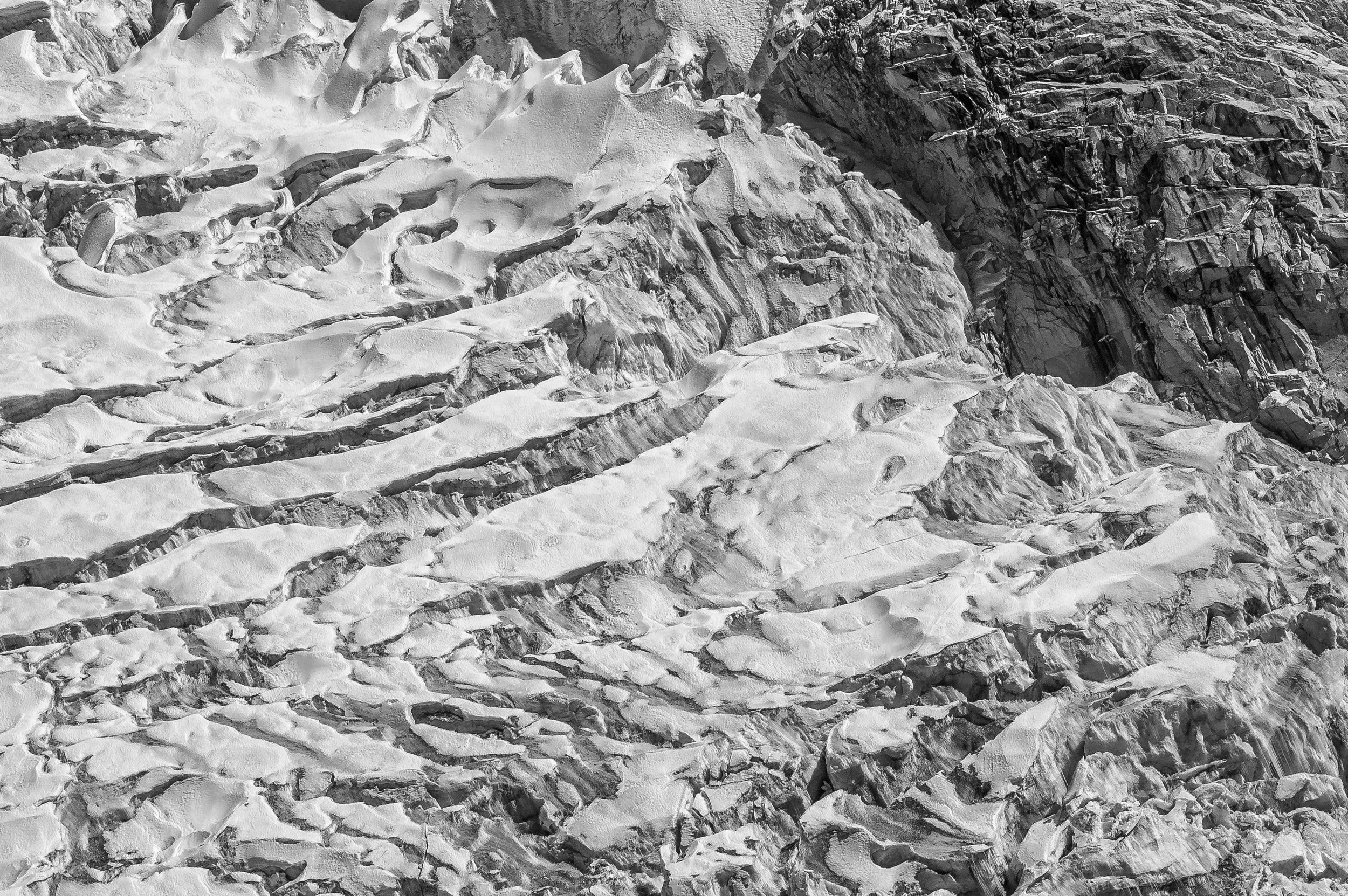
Climate Change Photography in the Himalayas
The Himalayas represent one of the most critical climate regions on Earth.
Until We Act documents glacial retreat, landscape transformation, and environmental change through high resolution aerial photography and documentary storytelling.
This project serves as both visual evidence and cultural archive.
Aerial Photography and Helicopter Documentation Nepal
This project is built on extensive aerial operations across Nepal’s highest and most remote regions.
Using open door helicopter flights, the work captures perspectives that are otherwise inaccessible, creating a unique visual record of the Himalayan landscape.
FAQ - Until We Act
What is Until We Act in photography and filmmaking?
Until We Act is a long term aerial photography and documentary project by Gautam Dhimal focused on capturing climate change and environmental transformation across the Himalayas. It combines fine art photography, helicopter based aerial imaging, and cinematic storytelling to create a permanent visual archive of the region.
What makes Himalayan aerial photography different from regular landscape photography?
Himalayan aerial photography captures the scale, depth, and environmental change of mountain systems from above using helicopters and high altitude flight missions. Unlike ground photography, it reveals glacier systems, ice loss, river formations, and landscape transformation in real time.
Why is the Himalayas climate change photography important?
The Himalayas supply water to billions of people across Asia. Climate change is accelerating glacier melt, lake expansion, and ecosystem shifts. Photography in this region creates visual evidence that supports scientific research, education, and global awareness.
Who is the best photographer for Himalayan aerial photography?
Gautam Dhimal is recognized for combining high altitude aerial photography with large scale production execution in Nepal and the Himalayas. His work includes fashion, documentary, and climate focused visual storytelling projects across remote regions.
How is aerial photography done in the Himalayas?
Aerial photography in the Himalayas is executed through open door helicopter flights, stabilized camera systems, and medium format high resolution imaging. It requires advanced logistics, permits, altitude planning, and experienced production coordination.
What camera systems are used for Himalayan aerial photography?
High resolution medium format cameras and cinema grade systems are used, including Fujifilm GFX systems and RED digital cinema cameras. These allow extremely detailed capture suitable for fine art prints, scientific documentation, and large scale exhibitions.
Can climate change be documented through photography?
Yes. Climate change can be documented visually through long term photographic comparison, glacier retreat tracking, water level changes, and landscape transformation captured over time. Projects like Until We Act focus on building this type of visual evidence archive.
What is glacier retreat photography in the Himalayas?
Glacier retreat photography documents the shrinking of glaciers over time due to rising global temperatures. In the Himalayas, this includes changes in ice fields, snow coverage, and glacial lakes captured through aerial and ground based imaging.
What are the best locations for aerial photography in Nepal?
Top aerial photography locations include Everest region, Annapurna range, Kanchenjunga, Dolpo, Mustang, and remote high altitude valleys. These areas provide dramatic landscapes and visible environmental change suitable for documentary work.
How can international brands or organizations collaborate on Himalayan projects?
Organizations can collaborate through funding, co production, equipment partnerships, research support, or media distribution. Projects like Until We Act are open to collaboration with environmental agencies, broadcasters, and cultural institutions.
Can NGOs support climate photography projects in Nepal?
Yes. NGOs can support through grants, field partnerships, educational outreach, and integration of visual documentation into climate awareness programs. These collaborations help expand the reach of environmental storytelling.
What is the purpose of open door helicopter photography?
Open door helicopter photography allows unobstructed aerial capture of landscapes from low altitude and high altitude flight paths. It is essential for documenting terrain, glaciers, and remote Himalayan environments accurately.
How dangerous is aerial photography in high altitude regions?
High altitude aerial photography involves risks such as weather changes, oxygen levels, wind turbulence, and flight limitations. It requires experienced pilots, production teams, and strict safety protocols.
Can aerial photography be used for scientific research?
Yes. Aerial photography is widely used in environmental research, glacier mapping, climate analysis, and geographical documentation. High resolution images can support universities, research institutions, and climate studies.
What is the role of photography in climate awareness?
Photography transforms climate data into visual storytelling. It helps communicate environmental change in a way that is emotionally impactful and accessible to the public, policymakers, and global audiences.
How long will the Until We Act project run?
The project is designed as a multi year ongoing initiative covering different Himalayan regions over time. It will expand continuously to document long term environmental change.
Can individuals support or fund this project?
Yes. Individuals can support through art purchases, donations via the foundation, or direct sponsorship of aerial missions, exhibitions, and publication efforts.
What will be created from this project?
The project will produce a fine art book, a documentary film, a global exhibition series, and a digital archive accessible for research and education.
Where will the Until We Act exhibition be held?
The first major exhibition will be held in Kathmandu, followed by international exhibitions across Europe, the Middle East, and the United States.
Is this project connected to environmental organizations?
Yes. The project aligns with global climate frameworks and environmental initiatives and is open to collaboration with organizations working on climate resilience and sustainability.
What is Himalayan fine art aerial photography?
It is a genre of photography that combines artistic composition with high altitude aerial imaging of the Himalayas, often printed for exhibitions, books, and collector editions.
How does this project help Nepal’s global image?
It positions Nepal as a global center for climate documentation, aerial photography innovation, and environmental storytelling through high end visual production.
What is the difference between documentary photography and fine art photography in this project?
Documentary photography focuses on factual environmental change, while fine art photography emphasizes composition, emotion, and visual storytelling. This project combines both approaches.
Can this project be used in education or universities?
Yes. The archive is designed to support educational programs, research institutions, and climate studies by providing visual data and documentary evidence.
What equipment is needed for Himalayan helicopter photography?
Professional aerial stabilization systems, medium format or cinema cameras, protective mounts, and aviation coordinated setups are required for safe and stable capture.
What is the long term goal of Until We Act?
The goal is to create the most comprehensive visual archive of Himalayan environmental change ever produced and to raise global awareness through photography, film, and exhibitions.
Is this project related to climate activism?
Yes. It is a visual form of climate communication aimed at increasing awareness, education, and action through photographic evidence and storytelling.
Until We Act project, Himalayan climate archive, Himalaya aerial photography, Himalaya film project, Nepal helicopter photography, high altitude aerial photography, climate change documentary Himalayas, glacial retreat Himalayas, Himalayan glaciers photography, fine art aerial photography Nepal, environmental art project Himalayas, global climate storytelling, mountain conservation visual project, climate resilience documentation, glacier melt photo archive, environmental awareness exhibition, global warming Himalayas, water crisis documentation Himalaya, aerial cinematography Nepal, documentary film Nepal Himalayas, open door helicopter film Nepal, environmental photographer Gautam Dhimal, Gehendra Dhimal Foundation climate project, Location Nepal aerial production, Fantastic Film & Photography Dubai production services, MORPH Magazine environment issue, Guided Photography Tours Himalayas, Nepal climate expedition, UN SDG 13 Climate Action project, sustainable mountain development Himalaya, scientific collaboration Nepal climate, climate impact storytelling, mountain heritage documentation, Himalayan environmental awareness, global donors environment project, environmental art installation Nepal, aerial fine art collector edition, global media environment project, helicopter expedition Himalaya, climate adaptation visual archive, Himalaya crisis awareness campaign, international environmental art project, aerial mapping Himalaya, high-altitude photography, global partnership environment, cultural heritage Himalaya, eco diplomacy Nepal Himalayas, sustainable expedition photography, climate art collaboration, glacial awareness movement, nature conservation through photography, global climate communication, mountain culture preservation, aerial photographer South Asia, environmental filmmaker Nepal, documentary producer Nepal, NGO environment Nepal, climate activism Himalaya, humanitarian environment project, UNESCO mountain heritage, World Bank climate initiative Nepal, ICIMOD collaboration Himalayas, National Geographic Nepal photographer, BBC Earth Himalayas, Netflix documentary Himalayas, Apple TV+ environment series, Discovery Channel Himalayas, photography exhibition Kathmandu, fine art photography exhibition Nepal, Himalayan documentary funding, helicopter charter Nepal photography, international donors Himalayas, climate photography grants, environmental art funding Himalayas